Last weekend we had what is probably the best experience so far in NZ. On Saturday morning I took a rental car south and picked up Giigan from the farm half way between Rotorua and Taupo. We continued to Taupo before making a stop to buy some groceries for the two days ahead. Taupo lies on the shores of Lake Taupo; the largest lake in NZ. On a clear day, the likes of one we were fortunate enough to be blessed with, you can see the peaks of three volcanic mountains south across the lake. These are in the heart of the Tongariro National Park. It was there we were heading.
 The three volcanoes of the Tongariro National Park across Lake Taupo.
The national park lies about 280 km south of Tauranga, so I had plenty of time getting used to driving on the left side of the road. I'm a bit suprised by how easy it actually is - at least with an automatic! I wouldn't want to shift gears with my left hand; that would feel very strange. The only thing I had problems with was the signal lights for turning. The lever for doing this was on the "wrong" side of the steering wheel, so almost every time I was turning, I put the window cleaners on! Then there's the stupid "give-way-to-cars-coming-from-your-right" rule, which doesn't make much sense if you're turning left yourself. Oh well, you just have to be sharp while behind the wheel.
The Tongariro National Park was given as a gift to the people of NZ in 1887 by the local Maori tribe. It is the first national park in NZ and the fourth in the world. It is the first in the world to have been gifted by the country's indigenous people and is today a
World Heritage park. The national park is centred on three active volcanoes; Mt Tongariro (1967 m), Mt Ngauruhoe (2291 m) and Mt Ruapehu (2797 m), but is surrounded by herb fields, hot springs, waterfalls, rain forests, alpine lakes and a desert-like plateau.
Mt Ruapehu is always covered with snow and ice and is home to the North Island's only glaciers. There are two ski areas on the slopes of the volcanoe. You may recognise the mountain from the Lord of the Rings movies, since some shots were taken there. The neighbouring Mt Ngauruhoe also featured in the movies and stood in fact as model for Mt Doom, which is quite obvious when you look at it :-) Mt Ngauruhoe is very beautiful with its near perfectly symmetrical slopes and circular top crater. It hasn't exploded to pieces like its two brothers.
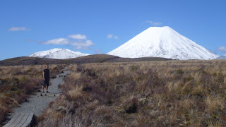 "Mt Doom" looks a bit different when snow covered, doesn't it? Almost like a gigantic pile of white sugar.
We stayed at a hostel in National Park Village, on the western fringe of the park. We didn't, however, spend much time there besides sleeping. After arriving around 2 o'clock on Saturday we immediately drove to Whakapapa Village, which is one of the ski areas at the base of Mt Ruapehu. There are many short walks starting from there. We headed out towards the Tamaki Falls; a 2 hour walk to a largish waterfall of about 20 metres. Most of the trail cut through a landscape which reminded us very much of Lapland, except that there were three stunning white-capped mountain peaks in the distance. The walk was very pleasant and served us as a suitable warm-up for what we were going to attempt on Sunday.
 At the Tamaki Falls.
On Saturday evening we went for a drink to The Station café/bar/restaurant in National Park Village. It was an idyllic place to relax; its reconstructed interior had a cozy atmosphere and the warmth of the fireplaces drove away the chill from our bones (it is still essentially winter in the national park).
On Sunday morning we woke up early at 6 o'clock and made ourselves ready for the day's walk. Along with a lot of other people we were going on the
Tongariro Alpine Crossing. This is a one-day trek - often rated as the best such in NZ - through steep volcanic terrain. The trek starts and ends at different points, so we had booked transportation with our hostel. The distance of the basic trek is 19,4 km and is estimated to take 6-8 hours. Once about half-way, you can choose to do two side trips if you have the time and energy. You can either climb to the summit of Mt Ngauruhoe (2287 m) or Mt Tongariro (1967 m). There is a poled route to the latter, but not to the first.
We wanted to do either one of them, so as we had only 8 hours in total from the time we were dropped of 'til we were going to be picked up at the other end, we set out at a rather brisk pace from the start at the Mangatepopo car park (altitude about 1150 m). The first hour of the walk all the way to Soda Springs was fairly easy. The route took us to the cleft between Mt Ngauruhoe and Mt Tongariro before starting to climb at a steep gradient. At an altitude of around 1500 m the trail got covered by snow. This made it a bit harder, but luckily it wasn't frozen and slippery so no clampons were necessary. Once you reach the saddle point between the two peaks and what is called the South Crater, you can choose to climb Mt Ngauruhoe.
 Still on the first and easy part of the walk. Mt Ngauruhoe to the left.
We would have loved to conquer "Mt Doom", but it's a 600 m climb from the South Crater at a very steep inclination. In other words: it looked tough! So we didn't do that but decided to instead climb the summit of Mt Tongariro which lies at the northern end of the South Crater. Besides, Frodo and Sam didn't have to climb all the way to the top of Mt Doom, so we are no worse than they are!
 The South Crater and Mt Ngauruhoe
From the South Crater the basic trek continues to the Red Crater at 1886 m. The volcanic rock of the crater is red (d'oh!) and there is steam rising from gas vents on the slopes of it. A reminder that this is still an active volcanic area.
From the Red Crater we took the side trip to the summit of Mt Tongariro. This is a 3 km return trip which climbs to 1967 m. It was pretty cold up there because of a strong wind, but the vista before us made the temperature insignificant. I just can't describe how awesome it was to stand there at the summit and see the majesty of the land unfolding before our eyes. Across the South Crater Mt Ngauruhoe pierced the deep-blue sky and from beyond, Mt Ruapehu looked back at us. Far in the horizon we could even see the peak of Mt Taranaki (2518 m) above the clouds. Mt Taranaki is a lone volcanoe about 150 km away on the west coast. We sat at the summit a few minutes eating muesli bars and dried dates before forced to start moving again by the freezing wind.
 At the summit of Mt Tongariro. Mt Ngauruhoe (left) and Mt Ruapehu (right) are behind us.
The second half of the Crossing starts by descending from the Red Crater to the Emerald Lakes. These are three small lakes with a beautiful blue-green-turqoise colour. Here we took another short break and enjoyed more muesli bars and refreshing juice.
 Descending from the Red Crater to the Emerald Lakes.
Before coming down below the snowline the trail took us over the flat plain of the Central Crater and passed the Blue Lake. Because we had made good time we were able to take an hour's break at the Ketetahi hut, just 1½ hours walk from the ending point of the trek. The hut lies on the northern slope of Mt Tongariro and has an astonishing view north towards Lake Taupo. We ate our late lunch consisting of boiled eggs and golden kiwi fruits there, sitting in the sunshine at the front of the hut. We felt immensely good!
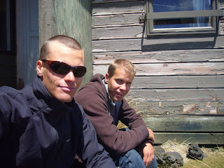 Felt good sitting down for a while at the Ketetahi hut and enjoy some refreshments in the warm sunshine.
All in all it took us 7,5 hours to get from the starting point to the end. Considering that we spent an hour walking the side trip to the summit of Mt Tongariro and another hour at the Ketetahi hut, we were quite fast! Guess we are both in pretty good shape :-) Still, it doesn't stop at least me from feeling the long walk in my legs even today.
So there you have it folks; a recipe for a terrific weekend!
MORE PICTURES from our adventure in the national park are available here!

 You're allowed to look a bit funny just before jumping out of an aircraft at 15,000 feet, right?
 The location of our bungy jumps. You can see the jump platform up to the right.


 Posts
Posts

