The drive got interesting again when we reached the latitude of Santa Cruz. We left the interstate and followed highway 152 past San Luis Reservoir State Park (a gigantic artificial lake, we think) and over the Coastal Ranges. It was a really nice drive which took us over the mountains to the sea and finally to our destination; the cozy seaside town of Monterey at the southern end of the Monterey Bay. The drive from LA took us 6 hours, the distance was roughly 600 km.
We immediately felt at peace in Monterey; the atmosphere was totally different than in LA - relaxed, friendly and safe. We checked in at the Hostelling International Monterey hostel, which proved to hold the high standard of other HI hostels, and then went for a walk.
Sadly the time was so much that we didn't have time to visit the Monterey Bay Aquarium which is supposed to be superb. It "explores the rich and varied sea life of the Monterey Bay National Marine Sanctuary". Well, you can't get everything and now we have something to visit in Monterey the next time as too.

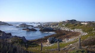
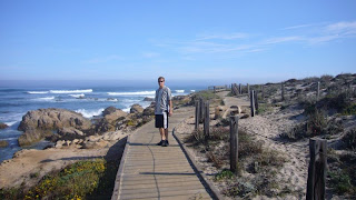
It was a warm and sunny late afternoon/evening so instead we decided to walk along the shore towards Pacific Grove, which is a small town just next to Monterey. It was absolutely gorgeous and the houses along the way were amazing! We walked for several hours but didn't quite stay long enough by the sea to see the sunset since the breeze from the Pacific got pretty chilly as the sun approached the horizon.


In the evening we did another walk to Cannery Row and Fisherman's Wharf, but didn't go for a fancy, expensive dinner even though the seafood looked delicious (we are budget travellers after all!). Our supper consisted of ham and cheese on crackers, washed down with Dr. Pepper. Yummy.
Next morning (Friday 29th August) we bought breakfast at Subway (only $5 for a footlong!) and took the most scenic route out of Monterey, i.e. through Pacific Grove along Sunset Drive (which we walked along the evening before) and via the Seventeen Mile Drive.
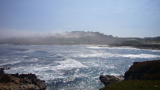
In the morning (we headed out at around 8:30) it was very foggy, but most of it cleared away as we parked on the shore in Pacific Grove and ate our subs. By the time we reached the gate to the 17 Mile Drive (yes it's a toll road but the $10 per car are well worth it) most of the fog had retreated to the sea. We have only one word to describe this scenic coastal route from Monterey to Carmel: amazing! If your're in the area it's a must drive. There are a lot of marked points of interest along the way, for instance beautiful beaches, bird rocks, lookouts and famous golf courses. The 17 Mile Drive area is the home of such well-known (at least if you play golf for real) courses as The Links at Spanish Bay, Spyglass Hill (which is open to the public) and Pebble Beach.


We can warmly recommend the 17 Mile Drive to everyone and suggest you start the drive from the Pacific Grove Gate as we did, since you then have easy access to the beachside resting points, vista points and other points of interest without having to cross the road. Also this way you don't have an extra lane to gaze over as your eyes are turned toward the shoreline and the waves of the Pacific.
Unfortunately we didn't get a good view of Pebble Beach Golf Links (much to JBB's annoyance) because there weren't any vista points and we didn't bother to stop there as there was a tournament in progress. We also missed "the Lone Cypress" which allegedly is one of California's most enduring landmarks, so we'll just have to visit both Monterey and the 17 Mile Drive in the future again! What a shame! *sarcasm*
We exited the road at the Carmel Gate, drove through smalltown Carmel along Ocean Avenue and continued south on Highway 1. It had taken us nearly 2 hours to complete the 17 miles plus the couple of miles from Pacific Grove to the starting point.
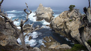
Our next stop came pretty soon, as Highway 1 passed Point Lobos State Reserve just 4 miles south of Carmel. Point Lobos S.R. is "the crown jewel of California's state park system" and has been said to be "...the greatest meeting of land and water in the world". We can certainly agree with that as the pictures will show you. Principally Point Lobos is a collection of extremely cool cliffs that the waves keep crashing into. Throw in some trees, beaches, birds, seals, sea lions and other aquatic animals and you've got a state park. We were certainly impressed. The park isn't huge, but we decided to take the car in instead of parking it half a mile short of the entrance and main gate and walk the whole way. It saved us a lot of precious time, even though the entry fee was $10 per car. On our way through the gate we once again got proof of the fact that Finland isn't such a well known country for everyone. The guard at the gate was really friendly and gave us some tips on what to go and see in the park. When he asked our nationality we answered that we were Finnish. The old man says OK and mutters something about checking to see if there are any guide booklets in our language. He half disappears begind the counter and reappers a few moments later saying "Danish! Here you go guys, enjoy your stay in the park!".
What a laugh we got driving away from the gate! The guy must have been thinking back there "What did those guys say? Something -ish, or maybe -nish... Let's see what we got here... hmm... Danish! Yes, that must be it!"
So we ended up with a Danish brochure, no harm in that, it was still readable, but funny none the less.


In the park we walked the Cypress Grove trail (Cypress Cove was spectacular, pictures above), the Sea Lion Point trail and the Bird Island trail. Although we occasionally heard the noise, we didn't see any Sea Lions on the Sea Lion Rocks due to a nasty fog that had rolled in from the Pacific. Still, we got remarkably plenty of sun while on Point Lobos and especially China Cove and Gibson Beach (pictures below) were painfully perfect in the sunlight. Bird Island was indeed very well named - it was all white from all the bird shit!


Before leaving we quickly drove to Whalers Cove, but didn't get out of the car since the place paled in comparison to the earlier sites we visited.
From Point Lobos we continued south along Hwy 1, our goal for the day being the little town (or cluster of motels if you prefer) San Simeon about 90 miles away. Between those two points the road snakes up along the steep cliffs right above the shoreline. Needless to say, the view is breathtaking. The view in the Big Sur area was particularly fantastic and the only downside was the cloud-/fogsheet lying over the Pacific. But the coast was clear and the sun was shining so we got a good look of the steep coastline plunging into the ocean. There were many vista points and turnouts where we stopped and took some pictures. Notable landmarks in Big Sur are the Bixby Creek Bridge and the Point Sur Lightstation (you can't actually drive there, but you can see the tremendous rock it lies on from Hwy 1).


We stopped for a couple of hours on the Pfeiffer Beach, which according to Drive Around California by Thomas Cook books is "Big Sur's best and hardest-to-find beach". The beach has no sign from Hwy 1 and is not visible from the road. The trick is to find Sycamore Canyon Rd, the only paved road west off Hwy 1 between the Big Sur Post Office and Pfeiffer-Big Sur State Park.

The secluded beach has some beautiful cliffs and a white strand. We enjoyed the sunshine from full horizontal positions, but didn't venture into the water due to dangerous undercurrents. (We saw one man playing ball with his two dogs and he had to rescue one of them once when it didn't have the strength to swim ashore. Another time a wave caught one of the dogs, which was turned upside down as it crashed into it. Looked very funny as four feet pointed skywards among the white foam for a moment, but not safe at all.)


From Pfeiffer Beach we drove without major stops to Hearst Castle right next to San Simeon. The beach at McWay waterfall in Julia Pfeiffer Burns State Park could have deserved a visit, but it was pretty late and paying an entrance fee again seemed excessive at that point (the fee to Pfeiffer Beach was $5 per car). Sadly we didn't have much of a view for the rest of the drive that day, as clouds and fog from the Pacific had rolled in over the coastline. The only point we saw clear blue skies at again was when the road climbed reeeeeeeally high above the clouds.

One thing to note when driving between Carmel and San Simeon along Hwy 1 is, that the distance is not long, but it takes a long time due to all sharp bends where you can't go faster than 30 km/h.
To finalize the description of the day, let's just say that we popped in to the Hearst Castle Visitor Centre (more on that in the next part), checked into our room at the Courtesy Inn motel in San Simeon, had dinner at the Manta Ray restaurant and went to bed!
*End of part 2, the last and final part will follow soon*


What can i say? Waaaay nifty. Wish i was there... but hey, greetings from beautiful, eh, Lohja!
ReplyDelete